When a Border Mix-Up Created America's Forgotten Territory That Nobody Owned
When a Border Mix-Up Created America's Forgotten Territory That Nobody Owned
Imagine living somewhere that technically doesn't exist on any official map. Not a remote island or hidden valley, but a strip of farmland where your great-great-grandfather built his house, completely unaware he was settling in legal limbo.
That's exactly what happened to residents of a small area along the Vermont-Quebec border, where a colonial-era surveying error created what might be the strangest territorial oversight in North American history.
The Mistake That Made a Missing Country
In 1783, the Treaty of Paris officially ended the Revolutionary War and established the northern border between the newly independent United States and British-controlled Canada. The boundary was supposed to follow the 45th parallel—a clean, mathematical line across the continent.
But 18th-century surveying wasn't exactly GPS-precise.
When surveyors finally got around to marking the actual border in 1818, they discovered something embarrassing: their measurements were off. The line they'd been using as the official border ran about three-quarters of a mile south of where the 45th parallel actually sits.
This created a peculiar problem. A narrow strip of land—roughly 5 miles long and three-quarters of a mile wide—had been treated as part of Canada for decades, but technically sat below the true border in what should have been U.S. territory.
Neither country wanted to deal with the mess, so they just... didn't.
Life in the Gap
For the families living in this cartographic purgatory, the surveying error created a bizarre kind of freedom. They found themselves in a place that existed physically but not legally—a real-world glitch where normal rules simply didn't apply.
Residents paid no taxes to anyone. Why would they? No government officially claimed them.
They couldn't vote in elections, but they also couldn't be drafted into military service. Local law enforcement from both sides generally ignored the area, creating a pocket of benign anarchy where disputes were settled by community consensus rather than courts.
One resident reportedly built a house that straddled the uncertain border, with his kitchen technically in Canada and his bedroom in the United States—though nobody could say for sure which room belonged to which country.
The postal service presented its own complications. Mail delivery required creative solutions, with some residents maintaining addresses in both countries depending on which postal system felt more reliable that week.
The Quiet Complications
While the freedom from government oversight might sound appealing, the reality proved more complicated than romantic.
Children born in the territory faced citizenship questions that no one quite knew how to answer. Were they American? Canadian? Stateless? Different families handled this differently, with some traveling to established territory for births while others simply hoped the paperwork would sort itself out eventually.
Business transactions became exercises in creative interpretation. Contracts, property deeds, and commercial agreements all required careful wording to navigate the legal vacuum. Some entrepreneurs actually used this ambiguity to their advantage, operating businesses that might have faced restrictions in either established country.
The area attracted a small but steady stream of people seeking to escape various obligations—debt collectors, angry spouses, and others who found the legal gray zone convenient for starting fresh.
The Resolution Nobody Noticed
By the 1840s, both governments quietly acknowledged that ignoring the problem wasn't making it disappear. But rather than create an international incident over a few square miles of farmland, they chose the path of bureaucratic discretion.
The Webster-Ashburton Treaty of 1842, which resolved several border disputes between the U.S. and British North America, included a barely-noticed provision that formally assigned the disputed strip to the United States. No fanfare, no ceremony, no official notification to residents.
Many families living in the area didn't learn about their new official citizenship until years later, when tax collectors finally showed up with bills.
The transition proved remarkably smooth, partly because the area had functioned as a de facto American community for decades anyway. Most residents spoke English, used American currency when they used currency at all, and had developed social connections primarily with Vermont communities to the south.
The Legacy of Legal Limbo
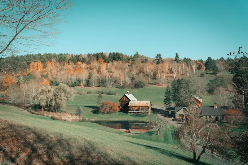
Today, the former no-man's-land looks like any other rural Vermont countryside—rolling hills, farmhouses, and the occasional historical marker that most people drive past without reading.
But the story serves as a reminder of how arbitrary our most fundamental assumptions about territory and citizenship can be. For two centuries, families lived full lives in a place that technically didn't belong to any nation, proving that human communities can thrive even when the paperwork hasn't caught up.
The surveying error that created this accidental territory has long since been corrected, but it left behind something more interesting than precise borders: proof that sometimes the most unbelievable situations are the ones hiding in plain sight, waiting for someone to notice that reality doesn't always match the official version of events.
In a world obsessed with boundaries and documentation, these Vermont families accidentally discovered what might be the ultimate loophole—a place where you could live free simply because nobody remembered to claim you.